Maps
Hungarian electronic navigation map of the Danube
The currently available Hungarian electronic navigation map of the Danube can be downloaded here
The operator of the PannonRIS.hu site, the National Association of Radio Distress-Signalling and Infocommunications, assumes no responsibility for the content and form of the downloadable material.
For more information, contact the creator of the map, OVF (National Directorate General of Water).
These electronic navigation maps contain the data of the section of the Danube 1811-1433 fkm from the survey results carried out in 2016, edited by the territorially competent Water Directorates (EDUVIZIG 1811 fkm - 1708 fkm, KDVVIZIG 1708 fkm - 1560 fkm, ADUVIZIG 1560 fkm - 1433 fkm). Due to the flood events, water construction works, and dredging that took place in the meantime, we do not assume responsibility for the correctness, errors, or omissions of the map information, or for direct or indirect damages resulting from the use of the electronic navigational chart. We do not agree to the further use or commercial exploitation of maps that are subject to copyright. The map is published for testing purposes for potential users (before the introduction of a regular service with guaranteed content for navigation). We welcome comments on content, form, and methodology to the address ris@ovf.hu or map@pannonris.hu.
International Danube electronic navigation charts
Links to the currently available international electronic navigation charts on the Danube:
Austria https://www.doris.bmimi.gv.at/inland-encs/downloads/inland-encs-inland-ecdis-standard-25
Bulgaria https://bulris.bg/river-information-services/electronic-navigation-charts
Czechia https://geoportal.plavebniurad.cz/web/Geoportal/Index_en
Croatia http://vodniputovi.hr/en/ris/enc-charts/
Germany https://www.elwis.de/DE/dynamisch/IENC/
Romania http://afdj.ro/en/content/inland-enc
Serbia http://www.plovput.rs/electronic-navigational-charts
Slovakia https://www.svp.sk/sk/uvodna-stranka/odstepne-zavody/oz-bratislava/riecne-informacne-sluzby/
Softwares
In the course of the EU research activity related to shipping, an international standard was defined in relation to the electronic navigation map. This standard was adopted by the Danube Commission, the Central Commission for Rhine Shipping and the United Nations Economic Commission for Europe (UN-ECE).
System requirements to use the map:
- a computer with a resolution of at least 1024x768 pixels, if possible
- software for displaying Inland ECDIS charts according to standards
If the computer is connected to a GPS receiver, it becomes possible to display the position of our own ship and thus the automatic map management becomes easier. The computer can also be connected to a radar device, so the combination of the map and the radar image enables navigation.
The corresponding program is currently available at the following companies (examples):
Chart World http://www.chartworld.com
Command & Control Technologies http://www.cct-international.com
Innovative Navigation http://www.innovative-navigation.de
SevenCs AG & Co. KG http://www.sevencs.com
NoorderSoft http://www.noordersoft.com
Periskal Group http://www.periskal.com
Tresco Engineering http://www.tresco.be
Videosail http://www.videosail.de
Thanks to the SevenCs company, a freely usable viewer program is available, which ensures the display of the ENC free of charge. This program is available from: https://www.sevencs.com/products/software-downloads/
After downloading and installing the SeeMyENC application, the S-57 standard maps can be loaded. After decompressing the map package that can be downloaded from the PannonRIS page, the map files can be loaded by clicking on the Load icon of the SeeMyENC application.
Please confirm the type of map issued when using the viewer:
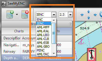
If the maps are stored in S-57 format, they can be loaded by clicking on the corresponding icon in the menu (the first icon from the left); it is possible to load several windows at the same time. If you look at the imported log files, they contain a number of error messages. We have checked these and they have no effect on the operation of the maps. Also, please note that you can open a maximum of 64 files at a time.
For the sake of completeness, it is not recommended to open all the data at the same time, only to load shorter parts.